Lake Lanier Custom Wood Maps: Combining Art and Topography
Discover stunning Lake Lanier map designs in custom wood. Merge art and topography to celebrate the beauty of Lake Lanier in your home.
Lake Lanier is one of Georgia's most popular recreational lakes, known for its scenic beauty, outdoor activities, and sprawling waters. This vast body of water stretches across 38,000 acres and is fed by the Chattahoochee and Chestatee Rivers. With such a large surface area and countless coves and inlets, navigating the lake can be quite a task, making detailed maps essential for visitors and locals alike. For those who love the lake and want to bring a piece of its grandeur into their homes, Lake Lanier custom wood maps offer a beautiful blend of art and topographical precision. Whether you're a boating enthusiast or simply someone who appreciates the lake's beauty, these wood maps serve as more than just navigational tools. They are works of art. A Lake Lanier map can display the lake's intricate topography in a visually stunning way, making it a prized piece for homeowners and lake lovers.
The Art of Custom Wood Maps
Custom wood maps combine craftsmanship, artistry, and precision to create a unique representation of a location's topography. These maps are often made by laser-cutting different layers of wood to represent varying elevations and depths. The result is a 3D effect that gives the map texture and dimension, making it a visually striking and tactile piece of art.
For Lake Lanier, a custom wood map can capture the lake's shorelines, islands, and underwater contours. These maps are not only aesthetically pleasing, but they also provide an accurate representation of the lake's layout, making them both functional and decorative. For people who enjoy spending time on the lake, such as boaters and anglers, having a wood map of Lake Lanier can serve as a great way to plan trips or reminisce about past experiences.
Why Lake Lanier is Perfect for Custom Wood Maps
Lake Lanier is known for its winding shorelines, numerous islands, and varied depth levels. These features make it an ideal candidate for a custom wood map, as the lake’s topography offers plenty of visual interest. The lake’s various coves and peninsulas can be highlighted through the layers of the map, giving a sense of depth and complexity.
Moreover, the lake's many islands, such as Pine Isle and the well-known Lake Lanier Islands, can be featured prominently. The changing water depths around the islands and shorelines can be represented by the use of different shades and wood types, adding another layer of artistic expression to the map. This combination of natural complexity and artistic craftsmanship makes Lake Lanier custom wood maps stand out among other topographical maps.
Creating a Custom Wood Map: The Process
Crafting a custom wood map of Lake Lanier involves several steps, all requiring attention to detail and a deep understanding of both the location and the medium. Here’s a breakdown of the process:
-
Topographical Research: The first step in creating a custom wood map of Lake Lanier involves collecting accurate topographical data. This data is usually sourced from GPS systems, hydrographic surveys, and other mapping tools that provide detailed information about the lake’s shape, depth, and terrain. This data ensures that the final product accurately represents the lake.
-
Laser Cutting the Wood Layers: Once the topographical data is collected, it is translated into a digital format. This allows the artist to use laser-cutting machines to carve out layers of wood that represent different depth levels or elevations. Each layer is carefully cut to ensure that the map maintains its accuracy.
-
Assembling the Map: After the wood layers are cut, they are meticulously assembled to form the complete map. Each layer is placed on top of the previous one, creating a three-dimensional effect that brings the lake’s topography to life. The shorelines, islands, and underwater contours all come together in a cohesive and visually stunning display.
-
Finishing Touches: Once the map is assembled, additional details such as labeling key locations, adding a frame, or applying finishes may be done. Some custom wood maps of Lake Lanier include labels for significant points of interest such as Buford Dam, Gainesville Marina, or Sunset Cove. These final touches add a personal element to the map, making it more than just a representation of the lake.
Benefits of Owning a Custom Wood Map of Lake Lanier
There are many reasons why people choose to invest in custom wood maps, especially of places like Lake Lanier. Some of the key benefits include:
-
Artistic Appeal: Custom wood maps serve as a unique form of wall art. They are much more than a standard print of a map – they are a 3D representation of the area, blending craftsmanship with geography. Whether placed in a living room, office, or vacation home, a custom wood map of Lake Lanier can be a stunning centerpiece that attracts attention and starts conversations.
-
Sentimental Value: For many people, Lake Lanier holds personal significance. Whether it’s family vacations, weekend getaways, or lifelong memories of time spent on the water, the lake is a special place. A custom wood map allows individuals to bring a piece of the lake into their homes, serving as a constant reminder of the good times spent there.
-
Educational Tool: Wood maps can also serve an educational purpose. For those unfamiliar with Lake Lanier’s layout, having a 3D map can help provide a clearer understanding of the lake’s structure. This is particularly useful for boaters, fishermen, and tourists who want to navigate the lake more efficiently.
-
Customized Options: One of the best parts about custom wood maps is the ability to personalize them. You can choose to highlight specific areas of the lake that hold special meaning for you or select different finishes and materials that match your home decor. Some maps even allow for the addition of custom labels, making them truly one-of-a-kind.
Where to Display Your Custom Wood Map
A custom wood map of Lake Lanier can be displayed in a variety of settings. Its versatility as both art and a conversation piece makes it a great addition to any space. Here are some suggestions on where to display your map:
-
Living Room: As a central piece of artwork, a Lake Lanier wood map can become a focal point in your living room. Its 3D layers and natural wood tones add warmth to the space and offer a rustic yet elegant vibe.
-
Vacation Home: For those who own a vacation home on Lake Lanier, a custom wood map is the perfect way to celebrate your love for the area. It can be placed in a dining room, hallway, or near an entryway where guests can admire it as they walk in.
-
Office or Study: If you want to incorporate a touch of nature into your workspace, a wood map of Lake Lanier offers a calming, earthy aesthetic. It serves as both a decorative item and a constant reminder of your connection to the lake.
-
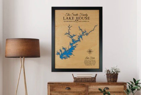
Lake House: For homes situated directly on Lake Lanier, displaying a wood map in a prominent area adds an authentic touch. It reflects the natural beauty of your surroundings and highlights the topography of the lake you call home.
Conclusion
Lake Lanier custom wood maps offer a perfect blend of art and topography. These maps showcase the intricate details of the lake’s shoreline, islands, and underwater contours while also serving as beautiful, handcrafted pieces of art. The detailed craftsmanship involved in creating these maps, combined with their artistic appeal, makes them an excellent addition to any home, vacation property, or office.
Whether you're a fan of Lake Lanier or simply appreciate finely crafted topographical maps, owning a custom wood map can be both a decorative and functional choice. They are versatile, customizable, and meaningful, offering a unique way to celebrate one of Georgia's most iconic lakes. With wood lake maps, you bring a stunning, natural representation of your favorite places into your living space, merging art and geography into a single, captivating piece.
What's Your Reaction?